

Not out of the blue: The Border agreement was years in the making, and St. Maarten helped shape it
.jpg)
GREAT BAY--The agreement over the border between St. Maarten and Saint-Martin did not suddenly appear in 2026, nor was it an arrangement developed entirely in The Hague without local involvement. The agreement now moving through the Kingdom legislative process was negotiated over several years, approved locally and at Kingdom level, and formally signed in May 2023 by then-Prime Minister Silveria Jacobs on behalf of the Kingdom of the Netherlands.
That history appears to have been forgotten in parts of the current public discussion. While the treaty is legally an agreement between the Kingdom of the Netherlands and the French Republic, the St. Maarten government was not a bystander, as some readers have suggested. Jacobs stated publicly in 2023 that the local government had been involved from the beginning, helped determine the negotiating mandate and adopted the compromise-driven position that eventually made an agreement possible.
As Jacobs stated in 2023: “I would like to stress that the realization of this treaty legally establishes the boundaries of the Southern and Northern territories of the island but does not undermine the oneness and unity that we speak of among the people that call this island home. The realization of this treaty, in fact, has several benefits for all citizens of our island. Clarity on the borderline removes ambiguity and facilitates our long-term planning and development.”
As France advances its own ratification and the agreement again draws public attention, it is worth revisiting how the process began, what St. Maarten agreed to and why the final boundary, particularly through Oyster Pond, differs from the simple equidistance line many people assume should have applied.
Why was a new treaty considered necessary?
The island has been divided between Dutch and French jurisdictions since the Treaty of Concordia was signed in 1648. However, that historic agreement did not define every part of the land boundary with the level of legal and technical precision required for modern government, property administration, development and enforcement.
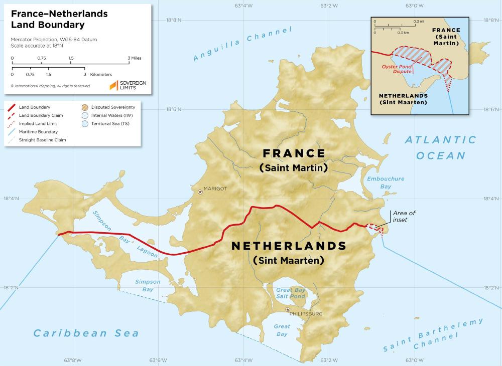
Disagreement became particularly serious around Oyster Pond. In 2014, French authorities challenged the Dutch-side position that all the water in Oyster Pond fell under St. Maarten’s authority. The dispute produced confrontations between authorities and placed strain on relations between the two governments. France later notified the United Nations of the international border dispute in December 2017.
The matter could ultimately have gone to international arbitration, but the Jacobs government argued that arbitration might resolve only the contested claim without creating a comprehensive arrangement for the entire border. In November 2021, St. Maarten adopted what government described as a more compromise-driven approach, helping to restart and advance the negotiations.
St. Maarten was directly involved
In May 2023, Jacobs was explicit about the local government’s role. She said St. Maarten had been “in the lead and wholly involved” in determining the mandate from the beginning of the process.
The negotiations were formally led by the Kingdom’s Ministry of Foreign Affairs because international treaties are Kingdom affairs. However, the process also involved St. Maarten’s Department of Foreign Relations, the local and Dutch cadastral authorities, the Ministry of Defence and local ministries including VROMI, TEATT and Justice.
The proposal also passed through approval channels within St. Maarten before receiving approval from the Kingdom Council of Ministers. This means it is not accurate to portray the treaty as something imposed without local government participation, even though the final international and constitutional procedures belong to the Kingdom.
“This agreement demonstrates our commitment to resolving differences through peaceful means and finding common ground for collective prosperity for our citizens. Together we embark on a new era of collaboration and shared progress solidifying our position as a nation that values peace, diplomacy, as well as positive engagement with our brothers and sisters in the North,” Jacobs said at the time.
Government signed the agreement in 2023
On May 26, 2023, Jacobs signed the border treaty at Belle Plaine/Belvedere on behalf of the Kingdom of the Netherlands. French Interior and Overseas Territories Minister Gérald Darmanin signed on behalf of the French Republic.
The signing followed approximately nine years of negotiations and came after the agreement had been technically developed and approved at the relevant ministerial and Kingdom levels. The treaty itself is officially titled the agreement between the Kingdom of the Netherlands and the French Republic concerning the demarcation of the border between St. Maarten and Saint-Martin.
Signing the treaty did not mean that it immediately became fully operational. It still required parliamentary approval through the Kingdom process and further implementation measures.
What does the agreement change?
The treaty establishes a legally defined boundary using hundreds of mapped coordinates. Technical experts identified 348 points to be incorporated into the official border map.
The most consequential changes include:
Oyster Pond divided between both sides
Instead of the entire pond being treated as Dutch territory, the border will run through Oyster Pond based on the internationally recognised principle of equidistance. The southern portion will fall under St. Maarten and the northern portion under Saint-Martin.
This gives the French side jurisdiction over the area that includes the former Captain Oliver’s Restaurant and Marina. Government acknowledged in 2023 that taxes and other public revenues connected to that location would consequently fall under the French jurisdiction.
Jacobs explained at the time that St. Maarten had issued rights primarily in relation to Captain Oliver’s, while many other persons operating in the area had dealt with the French authorities. Government believed this weakened the legal basis for claiming all of Oyster Pond if the matter proceeded to arbitration.
Adjustments at several land-border points
The agreed boundary shifts north in St. Maarten’s favour along the road in Cupecoy and along Marigot Hill Road. St. Maarten’s authority over Higher Bethlehem is confirmed, and the line along the road leading to Oyster Pond also moves north in favour of the Dutch side.
The border along the Belle Plaine road shifts west in favour of the French side. Taken together, the changes reportedly give St. Maarten approximately 7,109 square metres of additional land across several locations, while the French side gains the disputed water and jurisdictional area in Oyster Pond. The overall traditional division of approximately 16 square miles for St. Maarten and 21 square miles for Saint-Martin is not expected to change.
What rights does the treaty protect?
The agreement is not limited to drawing a line on a map. It also addresses practical issues that arise because residents, fishermen, businesses, property owners and authorities operate around a shared boundary.
The treaty includes provisions concerning access to the border, the placement and maintenance of boundary markers, navigation, mooring and small-scale artisanal fishing in Oyster Pond and Simpson Bay Lagoon. It also addresses activities and development near the border, including possible restrictions on new construction.
Jacobs said in 2023 that St. Maarten secured continued rights of access, navigation, mooring and artisanal fishing in both Simpson Bay Lagoon and Oyster Pond. The agreement also requires the authorities to address the rights and legal position of individuals or businesses affected by the new demarcation.
The treaty further provides for a joint border commission and a cooperation platform through which the governments can handle border markers, access questions, disputes and other cross-border matters.

What is happening now?
The treaty signed in 2023 has not simply disappeared. It is now moving through the formal ratification processes required in France and the Kingdom of the Netherlands.
On Thursday, July 16, 2026, the French Parliament ratified the agreement, formally approving France’s participation in the treaty. The vote means France has completed its parliamentary ratification process, but the agreement cannot yet enter into force because approval is still required through the Dutch Kingdom legislative process.
The French decision is therefore an important step, but it does not mean that the new boundary became legally operational today. The treaty will take effect only after both countries have completed their respective constitutional procedures and formally notified each other that those requirements have been met.
On the Kingdom side, the Dutch Minister of Foreign Affairs submitted an amended proposal for a Kingdom Act and an amended explanatory memorandum in May 2026, following advice from the Council of State of the Kingdom. The documents clarify how the treaty relates to the Treaty of Concordia, the maritime boundary treaty and international maritime law.
The Council of State also requested greater clarity about which provisions could directly create rights or obligations for residents and businesses. The revised documents identify provisions relating to boundary signs, access to the border and construction restrictions as potentially having direct legal effect.
The proposal must still be considered through the Kingdom legislative process, including by the Dutch Parliament, while St. Maarten’s Parliament has the right to examine the proposal, submit its views and participate in the process under the Kingdom’s treaty-approval procedures.
Local legislation may also be required to implement parts of the agreement, particularly where it affects residents, businesses, property rights, access and development near the border.